
The first European sighting of the Cocos (Keeling) Islands is thought to have been in 1609, by Englishman Captain William Keeling of the East India Company. Soon after, the two atolls that comprise the islands started to appear on maps.
These stamps show details of various Italian, French, Dutch and English maps over 400 years from the 17th to the 20th centuries. Each stamp is composed of various maps from a particular century: 17th, 18th, 19th and 20th.
Designer
Boschen Design
Products released in this issue
- Stamps 2 x 70c, 1 x $1.40, 1 x $2.10
- Covers (blank pictorial and gummed)
- Gutter strips
Technical specifications
- Issue date
- 24 June 2014
- Issue withdrawal date
- 31 December 2014
- Denominations
- 2 x 70c, 1 x $1.40, 1 x $2.10
- Stamp design
- Boschen Design
- Product design
- Sharon Rodziewicz, Australia Post Design Studio
- Paper - gummed
- Tullis Russell
- Printer - gummed
- RA Print
- Printing process
- Lithography
- Stamp size
- 35mm x 35mm
- Perforations
- 14.286 x 14.286
- Sheet layout
- Module of 50
- FDI postmark
- Cocos (keeling) Island, WA 6799
- FDI withdrawal date
- 23 July 2014

This stamp is composed of three 17th century maps. In 1646 Englishman Robert Dudley’s L’Arcano del Mare (Secrets of the Sea) was published in Italian in Florence. It was the first atlas of sea charts in the world. On this map the Cocos (Keeling) Islands were called the Triangular Islands and North Keeling Island is labelled “Riling Island”.
The figurative detail on the right is from the cartouche of a c. 1690 map of the south-east Indies, Indiae orientalis, by the Amsterdam mapmaker Nicolas Visscher II. It represents “oriental” figures engaged in trade in the East Indies against a backdrop of palm trees.
The lower border and the sun compass rosette on the left are from a 1666 map by Amsterdam mapmaker Pieter Goos, Paskaerte Zynde t’Oosterdeel van Oost Indien from his Zee-Atlas. This map was the first to represent Christmas Island.

The details on this stamp are from two 18th century maps, both of which refer to the islands as the “Isles des Cocos”. The first is a French map, Hémisphère oriental ou Ancien Monde prepared by JB Nolin and published by Louis Joseph Mondhare in 1783 for his Atlas Général a l'usage des colleges et maisons d'education.
The second, from which the lower border and lower reference to “I. des Cocos” are taken, is a German map published by JN Bellin in Leipzig in 1758, Karte von dem Morgenländischen Ocean oder dem Indischen Meere.

In the 19th century the islands were settled first in 1826 by Alexander Hare and again in 1827 by John Clunies-Ross, who landed with Malay seamen to exploit the coconut palms.
After settlement the early inhabitants called them the Borneo Coral Reefs after the supply vessel the Borneo, owned by John & Joseph Hare & Co and captained by John Clunies-Ross. They were also known as the Keeling-Cocos Islands. In his sailing directory compiled in 1805, British hydrographer, James Horsburgh, called them the Cocos-Keeling Islands and named one of the islands after himself.
In 1886 Queen Victoria granted the lands to George Clunies-Ross, retaining certain rights to the Crown, and in 1903 the Cocos group was incorporated with the Settlement of Singapore, having previously been under the control of the government of Ceylon.
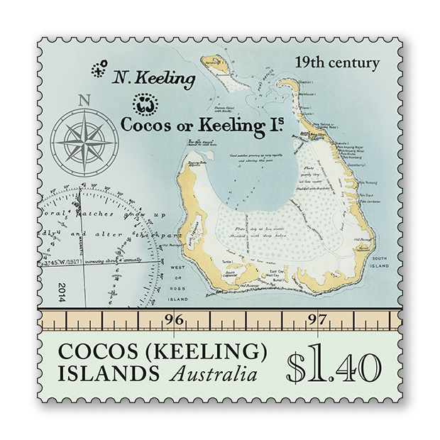
This stamp is composed of three 19th century maps. The representation of the islands (with Horsburgh Island appearing near the top of the stamp) is from a map that appeared in the Scottish Geographical Magazine in 1889, prepared by the Edinburgh-based Bartholomew map publishers.
The smaller reference to the “Cocos or Keeling Islands” at the top left is from a map The Indian Ocean published by the British Hydrographic Department in 1870 and the compass markings in the lower left are from a map of the Cocos or Keeling Islands as surveyed by Robert FitzRoy in 1836. Vice-Admiral Robert FitzRoy was the captain of the HMS Beagle during Charles Darwin’s second voyage of 1831–6, which reached the Cocos (Keeling) Islands in April 1836.

In 1955 the Cocos Islands were placed under Australian administration as the Territory of Cocos (Keeling) Islands.
This stamp shows Home Island marked on a map published in 1986 by Geoscience Australia. Home Island is one of only two permanently inhabited islands of the 27 that comprise the Cocos (Keeling) Islands. It is the home of around 500 Cocos Malays and is also the location of Oceania House, the original home of the Clunies-Ross family.
This content was produced at the time of the stamp issue release date and will not be updated.


 Islands Pandanus")
/2015-08-25_Islands_of_Cocos_(Keeling)_01_Pulu-Klapa-Satu_70c.png.auspostimage.560*0.11.medium.png "Islands of Cocos")
 Islands: Booby Birds")
 Islands")